

Satellite based ground motion surveys
for environmental safety and security
Satellite based ground motion surveys
for environmental safety and security

Land Motion Surveys for Environmental Safety and Security

Our Unique Capabilities
The Terra Motion Advantages
Many businesses around the world offer to measure ground motion using EO data.
None can offer a comprehensive service over rural and natural terrains.
Terra Motion have uniquely solved this problem and can offer services over all terrain types and on a global basis.
Independently tested and validated.
Patent Pending.
We can address new markets and applications because of this, and play an important role in the fight against climate change.
Our Services
Supporting ground stability data for property transaction risk analysis.
Providing information on natural perils for property insurance (cavitation, peat shrinkage, frost heave, soft and compressible soils).
Monitoring potential environmental effects on property and infrastructure (pipelines, roads and railways).
Management of sub-surface assets (mines, oil and gas extraction and storage, CCS, geothermal sites).
Management of surface assets
(open pit mines, dams).
Measuring the dynamics of a peatland surface for climate change applications.
Ubiquitous Ground Monitoring
▸Award-winning ISBAS algorithm developed to bring near-complete coverage of measurements over natural and vegetated terrain, as well as urban areas.
▸Our solution is constantly evolving to increase resolution, accuracy and to support new applications.
▸Underlying solution is developing towards increased automation and cloud processing.

APSIS© Survey
Subsidence and Heave due to Legacy Coal Mines
High Precision and Detail
Motion can be assessed and monitored on a regular basis to support asset management and risk assessment.
Results are easily integrated with existing ground data.

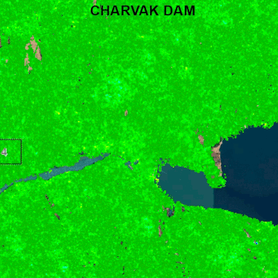
Charvak Dam, Uzbekistan
Subsidence
Dam
Landslide
Reservoir

Full Spatial Characteristics
Full coverage means the entire spatial extent and dynamics of the motion can be visualized.
We can also perform a stereo analysis to provide 2D motion vectors*.
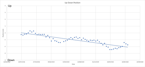
▸Up-Down
▸East-West
We can address new markets and applications because of this, and play an important role in the fight against climate change.
*subject to data availability

Landslide
Up - Down
Subsidence
Dam
Reservoir
Landslide
East - West
Subsidence
Dam
Reservoir
High Density of Measurements
High density measurements mean a more complete picture of the motion.
This helps to identify the full extent of any hazards, what is affected, the cause of the motion and the possible mitigation.
Our surveys provide a higher density in urban, as well as rural areas.
Crossrail Subsidence, London

Conventional InSAR Survey

APSIS© Survey
Deep Insights into Underground Resources
Our high-density maps of surface motion can be used to monitor fluid motion deep underground.
This can be used to:
▸Verify the amount of fluid injected/extracted
▸Calibrate geomechanical models
▸Provide early warning of problems
▸Ensure integrity
▸Measure any leakage


CO2 Enhanced Oil Recovery
From: T. Anderson, searchanddiscovery.com, 2013
APSIS© Survey
GeoMoves UK Product
▸A complete land movement map of the
UK land surface
▸Updated every year
▸Covers entire land surface at 20m
▸Supports markets in property transactions
and insurance

Complete Coverage

Urban and Rocky Areas